Roseberry Topping
OS grid reference:- NZ 579 126
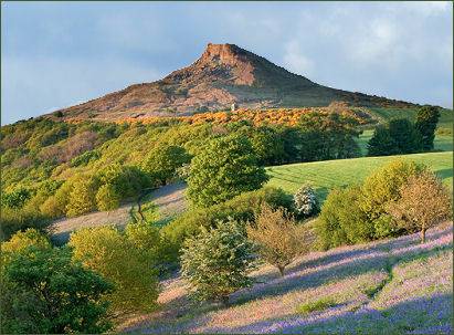
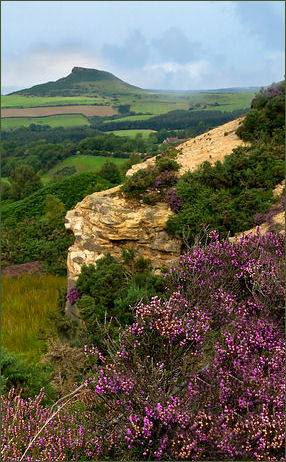 Roseberry Topping, an iconic hill, is situated near the villages of Great Ayton and Newton under Roseberry, on the western edge of the North York Moors National Park.
The hill which rises to a height of 1,049 feet (320 metres) is visible from many miles away. Its summit has a distinctive half-cone shape with a jagged cliff, which has led to comparisons with the much higher Matterhorn in Switzerland. It forms a symbolic image of the area and featured as the logo for the now defunct county of Cleveland.
Its shape is the result of the the combination of a geological fault and a mining collapse in 1912 Views of the Freebrough Hill, Cleveland Hills, the North Sea, Eston Nab, the Wainstones, Great Ayton and the 'Teesside' conurbation may be had from its summit, it is possible to see as far as the Pennines on a clear day.
A Bronze Age hoard was discovered on the slopes of Roseberry Topping and is now on display at Sheffield City Museum. It was occupied during the Iron Age; walled enclosures and the remains of huts dating from the period are still visible in the vicinity.
 The Vikings who settled in Cleveland during the early medieval era and, gave the area many of its place names. They gave Roseberry Topping its present name: first attested in 1119 as Othenesberg, its second element is accepted to derive from Old Norse bjarg ('rock'); the first element must be an Old Norse personal name, Auðunn or Óðinn, giving 'Auðunn's/Óðinn's rock'. If the latter, Roseberry Topping is one of only a handful of known pagan names in England, being named after the Norse god Odin.
The famous eighteenth century explorer James Cook was born a few miles to the north in a cottage at Marton. In 1736, Cook's family moved to Airey Holme Farm at nearby Great Ayton. The young James would often climb up Roseberry Topping, which gave him his first taste for adventure and exploration. In the nineteenth century it was proposed that a pyramid be built on top of the hill to honour his achievements. The plan, fortunately was was abandoned and an obelisk was instead erected on nearby Easby Moor.
Roseberry Topping is now managed by the National Trust and is open to the public. A spur of the Cleveland Way National Trail runs up to the summit. The hill can be approached from several directions by foot, the most common trails being from Newton-under-Roseberry, the car park beyond Gribdale Terrace, or Great Ayton.