Piercebridge Roman Fort
OS grid reference:- NZ 216 153
 Piercebridge Roman Fort, perhaps originally known as Morbium or Vinovium, is situated in the village of Piercebridge on the banks of the River Tees.
Undulations in the village green at Piercebridge reveal that the Roman fort lies beneath it. Dere Street was the main road, or Via Principalis which linked York with Hadrian's Wall at Corbridge. Artefacts unearthed in the village suggest that Romans occupied the site around the river as early as 70 AD, possibly due to the fact that there was a ford or ferry to be defended from the Brigantes. A civil settlement in the Toft field had grown up by 125 AD, and a military installation alongside Dere Street south of the Tees appeared in the late 2nd century.
The fortifications which we see today on the north side of the river were not constructed until 260 to 270 AD, when the other Roman settlements and vicus north and south of the river began to decline in size. The fort was maintained from around 290 to 350 AD, with later development, by which time the inhabitants were mostly inside the fort area. It was inhabited until the fifth or sixth century.The fort appears to have followed the standard Roman plan, being rectangular in shape with towers at each corner and two big gates for entrance and exit from Dere Street. Inside there would have been barracks, workshops, granaries and the garrison headquarters with the commandant's separate accommodation.
 The first bridge across the River Tees on the site was wooden, constructed in around 90 AD, but some point in the late 2nd century the wooden structure was washed away. Remains of bridge timbers have been discovered beneath the water.
A second bridge was built about 200 yards downstream from the original. The main bridge structure was of timber, but the timber was this time supported by stone abutments and a series of five thick masonry piers. The builders also laid down a series of paving blocks in the river bed to prevent damage to the piers from the river. Over time the river changed course, moving gradually northward. The southernmost abutment silted up in the 4th century, the Romans then built a metalled causeway leading to the bridge, protected by a retaining wall of limestone blocks.
The first bridge across the River Tees on the site was wooden, constructed in around 90 AD, but some point in the late 2nd century the wooden structure was washed away. Remains of bridge timbers have been discovered beneath the water.
A second bridge was built about 200 yards downstream from the original. The main bridge structure was of timber, but the timber was this time supported by stone abutments and a series of five thick masonry piers. The builders also laid down a series of paving blocks in the river bed to prevent damage to the piers from the river. Over time the river changed course, moving gradually northward. The southernmost abutment silted up in the 4th century, the Romans then built a metalled causeway leading to the bridge, protected by a retaining wall of limestone blocks.
To the east of the fort in Tofts Field, is a vicus, or civilian settlement, which dates from the 1st century AD and survived into the early fifth century. From the evidence of cropmarks, it consisted of about thirty buildings whose inhabitants probably traded via the river from the late 1st century. This vicus probably followed the building of the Roman villa south of the river at Holme House, which in turn began as a native roundhouse. There was an associated vicus at the other side of the river crossing, at Cliffe, in Yorkshire.
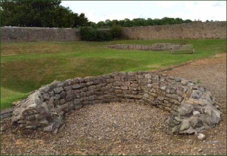 A Roman bath house was still standing at the south-east corner of the fort-site in the thirteenth century when St Mary's chapel at Gainford was built to incorporate part of it, possibly the wall with rounded arched doorway which is still visible from a distance, standing on private land. As was traditional, the garrison bath house stood outside the fort itself.
. An excavation was carried out on the site in 1938, which discovered a guard chamber at each side of the western gateway. The excavation also exposed the wall of the outer rampart, near the north-west corner and part of the south outer wall. A further excavation was carried out by Dennis Harding and Peter Scott between 1969 and 1981. A 1973 dig found a rectangular building with hypocaust dating to the third century. A bronze figure of a ploughman with oxen, which is now in the British Museum, was found here along with Roman coins dated early fourth century. St Mary's 1855 church building at Gainford contains Roman carved stones from the site. Other finds included kilns and Roman pottery, a metalworking site, a carved stone altar and burials including gravestones and a lead coffin. The site has been reassessed by archaeologist Dr David Mason in 2006, and the archive and arefacts from the excavations are at the Bowes Museum at Barnard Castle.
The television series Time Team investigated Piercebridge Roman Fort in 2009, and at that time divers examined holes in the river bed. Among the finds were a small lead goat and a hairpin. Inscriptions found attest to the presence of members of the Legio II Augusta, the Legio VI Victrix, and the Legio XXII Primigenia, as well as worship of Jupiter and Mars.
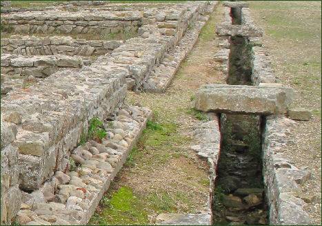
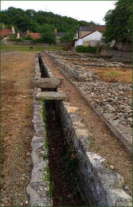
The eastern wall which can be seen today. The original rectangular defence pits are lawned over between the wall and the outer ditch. There were obstacle pits, and also man-traps or camouflaged holes spiked with large, pointed, wooden stakes for unsuspecting attackers to fall into. Beyond the fort wall was a road with a drain or culvert which still exists. The commandant's substantial house is beyond this road. The commandant had his own bath-house, and this is the one at the north of the site on private property. A large proportion of the substantial 11-acre (45,000 m2) fort now lies under later buildings. Visible Roman remains at the eastern part of the site include parts of the east gate and defences, a courtyard building and an internal road, and a section of the eastern elevation is now preserved and on permanent public display.
Admission is free and the site is open to the public all year round.
Directions
4 miles west of Darlington, on B6275. Sat Nav-Latitude: 54.534252. Longitude: -1.669234
Historic Buildings of Yorkshire