Gaping Gill
OS grid reference:- SD 751 727
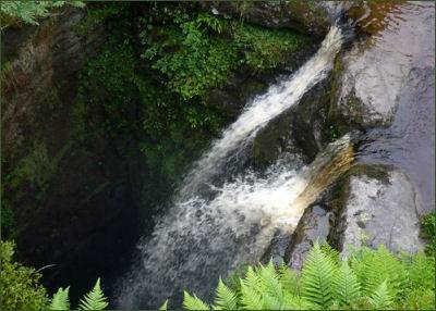 Gaping Gill is situated on the limestone moorland on the south west slopes of Ingleborough at an altitude of 1300 feet (400 metres).
Fell Beck plunges into a 98 metre (322 feet) deep pothole, after falling through one of the largest known underground chambers in the British Isles, the water disappears into the rocky floor of the cathedral sized chamber and eventually re-emerges as Clapham Beck at Beck Head Cave a short distance from the main entrance of Ingleborough Cave.
Gaping Gill is the highest unbroken waterfall in England and the largest underground chamber naturally open to the surface. The huge main chamber measures 145 metres in length, 25 metres wide and 35 metres in height and is large the nave of York Minster would fit inside it.
Due to the number of entrances which connect into the complex cave system, there are many different routes through and around the system. Other entrances include Jib Tunnel, Disappointment Pot, Stream Passage Pot, Bar Pot, Hensler's Pot, Corky's Pot, Rat Hole, and Flood Entrance Pot.
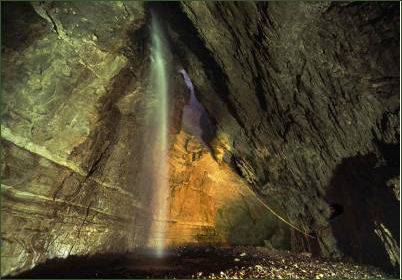 The deep main shaft and main chamber of Gaping Gill are extremely dangerous, and their exploration is usually available only to experienced potholers. The Bradford Pothole Club set up a diesel operated winch above the shaft to provide a ride to the bottom and back for the public upon payment of a fee, around Whitsun May Bank Holiday. The Craven Pothole Club do the same around August Bank Holiday, allowing members of the public and non-cavers the chance to visit the amazing underground chamber.
Local legend once stated that the fissure of Gaping Gill led down into hell. The first recorded attempted descent of Gaping Gill was made by John Birkbeck in 1842 who reached a ledge approximately 55 metres (180 feet) down the shaft, known today as Birkbeck's Ledge. The first complete descent was achieved by Édouard Alfred Martel in 1895, using a rope ladder, with a candle for illumination.
The Yorkshire Ramblers Club lowered cavers into the main chamber via a pulley system in 1896, they explored the main chamber and discovered the Old East Passage and West Chamber. In 1983 members of the teams the Bradford Pothole Club and Cave Diving Group made the underwater connection into Ingleborough Cave, although this had been previously proven by the use of florescent dyes.