Ingleton
OS grid reference:- SD 691 729
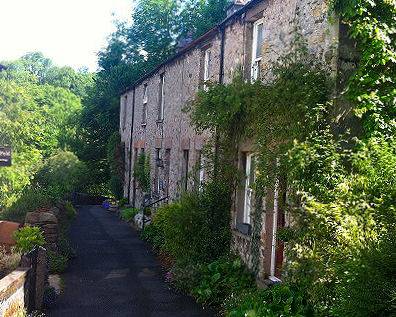 The Yorkshire Dales village of Ingleton is situated in the Craven district and lies 9.3 miles (15 km) from the small market town of Settle.
 Ingleton is surrounded by magnificent countryside, above ground, glaciers have created spectacular scars, limestone pavements, high cliffs and deep dry gorges. Below ground, the limestone region has many underground rivers, potholes and caves.
The village sits at the foot of Ingleborough (pictured below left), which at 723 metres (2,372 feet), the second highest mountain in the Yorkshire Dales. It is one of the Yorkshire Three Peaks, the other two being Whernside, at 736 metres (2,415 feet), and Pen-y-ghent, at 694 metres (2,277 feet).
Ingleton is situated at the junction of two rivers. The River Twiss from Kingsdale and River Doe from Chapel-le Dale combine to form the River Greta at Ingleton.
White Scar Cave, located a mile and a half from the village is the longest show cave in Britain. The cave was discovered in 1923, by Christopher Long, a student at Cambridge, while on holiday in the Yorkshire Dales, he came upon a hole in the hillside that seemed to go on for ever. There is also a former Victorian show cave known as Yordas Cave in nearby Kingsdale.
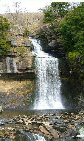
The famous Ingleton Waterfalls Trail begins and ends in Ingleton. The trail, which opened in 1885, is 8 kilometres (5 miles) long with a rise of 169 metres (554 feet) has some of the most spectacular waterfall and woodland scenery in the north of England. It passes through ancient oak woodland and magnificent scenery via a series of stunning waterfalls and geological features.
The village church of St Mary occupies the site of an earlier church, it was designed by Cornelius Sherlock and dates mainly from 1886, although the perpendicular tower dates to the fifteenth century. The Norman font dates to about 1150, it also contains a Vinegar Bible and a reredos with a carving of the Last Supper. The building stands on a bank of boulders and sediment from the last ice age which caused its foundations to become unstable. The nave was replaced on new compacted foundations in 1743 but demolished in 1886 to make way for the present one.
Ingleton and its surrounding area was inhabited in the Iron Age by the Brigantes tribe who built a hill fort on top of Ingleborough. On the arrival of the Romans, a further fort was constructed alongside the hill fort. By the twelfth century the Normans had built a church in the village.
William Lowther (1574-1641) of Ingleton Hall was Lord of the Manor, and a Justice of the Peace for the West Riding. The manor passed to his son Richard (1602-1645). His daughter Frances (1612-1665) married John Walker who leased the Ingleton Colleries, and Elizabeth (born 1615) married Anthony Bouch in 1636 and mortgaged Ingleton Manor.
Col. Richard Lowther was governor of Pontefract, and a member of the junior line of the Westmorland gentry family. During the Civil War he fought, along with his son Gerrard, on losing Royalist side at the Civil War siege of Pontefract Castle in 1645, and later at Newark. When the war ended and his father had died, Gerrard was fined for his adherence to the Royalist cause and the title of Lord of Manor passed to Anthony Bouch by 1665, while the coal rights passed to the Walker family.
The author Arthur Conan Doyle visited the area frequently and was married locally, as his mother Mary Doyle lived at Masongill from 1882 to 1917. There is evidence to support the claim that the inspiration for the name of his character Sherlock Holmes came from here. The area below the prominent viaduct that crosses the valley in the village is called the Holmes, while St. Mary's Church Ingleton contains a memorial to Randall Hopley Sherlock, brother of the vicar, Todd Sherlock who was struck and killed by lightning at Ingleton station. Mary Doyle lived in Masongill from 1882 to 1917, and Conan Doyle would have arrived by train at Ingleton railway station and continued his journey to Masongill by cart. This would have taken him through Holme Head.
Towns and Villages of Yorkshire